Tuesday, December 3, 2013

News and crazy idea

So it has been quite a while now without posts. Well life can't be always as exciting as last year.
At the moment Julien is working at MEC in Edmonton while Piia is enjoying her last moments of wilderness in Alaska.

After our challenging backpacking adventure this summer I (Julien) thought that I was done with long distance backpacking for a while. Well I always say that and two months after I dream about going back in the mountains.

For a few weeks I have been looking for different possibilities until the ultimate idea came to my mind :
Baffin Island
This island is located in front of Greenland, most of it is in Arctic area. It's really remote, without any high vegetation and the average temperature in July is about 8°C. This is a totally crazy idea, I mean, I'm thinking that we might be able to cross the island from south to north by walking about 1400 km next summer.

So for now, we have about 10% chance to really do it as it is a big project on which we have to work a lot if we want to do it safely. What I will try to do is to share in this blog the different steps that could eventually lead us to the Baffin Island ,or not. Including how we investigate the area, the mapping methods used, the first thoughts about the gear. Meaning all the steps which are in my opinion important while planning a pretty serious expedition like that.

So let's summarize :
-Monday - I get the idea while watching http://www.panoramio.com/, the landscapes are amazing, that looks challenging, not so much vegetation so we would be free to adapt our routes. Okay, project launched.
-Tuesday - Research online, first measurement between the communities using google map. It looks like the distance between the communities through the most interesting area of the Island (East coast), is about 1000-1400 km so our ideal length. Evaluation of first problems : Cold and windy climate, really technical terrains, high density of polar bears on the coast, many glacier to go through.
-Wednesday - Study of climate data using http://en.allmetsat.com/climate/nunavut-baffin-ellesmere.php . Then on google earth I tried to adjust the first draft in order to avoid the most difficult glacier, I mainly focused on the glacier issue and not really on wildlife or terrain issues, that we come after with the input of local advice. The route look like that after this step.

View Larger Map

So a reasonable plan would be to leave from  Pangnirtung and head to Pond Inlet on the North side. The glaciers issue as well as the river crossing issue might be resolved by the use of a packcrafs. (https://www.alpackaraft.com/index.cfm/store.catalog/Packrafts/Alpaca)
-Thursday - Research on the possibility of making a food drop after about 700km. At this point Google Earth is not accurate enough to be able to have a good idea of the terrain, I switched to some GIS data found on earthexplorer.usgs.gov , i focus on some elevation layer (DEM from ASTER) as well as some Landsat 7 ETM+ images which will allow me to assess the shape of the glacier in late July. There isn't any Topographic maps of Baffin Island that we could use so the data downloaded will be used to create our own Topographic map.
-Friday - I mostly plaid with the map on QGIS (http://www.qgis.org/en/site/) which is a free and open-source GIS software. I merged all the images together in order to get a full coverage of the area and produced the contour lines of our future topographic maps.

Contour lines produced on Qgis
 
Relief map, will help for the route planning

-Saturday - Obviously this adventure will be really expensive so I began to look at the costs in gears, logistic and food. I contacted the national parks office and some locals in order to get their feeling about what we plan to do.
-Sunday - We might be able to use some kind of trolley in order to not carry too much on our bags, the terrain seems appropriate to this system. There is a small community : Clyde river located at about half way to Pond Inlet. It is on the coast but it seems possible to reach it by doing a small detour. That might be an interesting option to consider. The layer showing the glacier are now ready and wow, this place looks amazing from a satellite point of view!
Landsat mosaic around Pangnirtung


So here was a short summary of a crazy week. I haven't slept so i was excited about this idea. As I said before it might never happen but we won't know until we try to make it happen so here we are officially trying.

This is just us showing how we plan things, we are not experts and might be a bit messy in our way of doing but you know sometimes you feel like checking maps sometimes you feel more like checking out some gears. The main point is to keep track of everything so everything that is done doesn't have to be done again, in those kind of period my bookmark folder get heavier and heavier every hours :D.

Piia is joining me in Edmonton in about a week, she will be able to give her point of view and to take her share of the huge amount of work that we have to accomplish if we want to go there.

See you soon!

Sunday, September 22, 2013

Fall in Yukon

So the summer passed by. The last weeks we have enjoyed Yukon and witnessed amazing fall colors. The weather has got cooler and night temperatures are often below freezing. We love autumn! 


After travelling many months we wanted to stay in Yukon for a few weeks before going back to Alaska. We were very lucky to find a place to stay in Tagish (80 km from Whitehorse) where our musher friends Michelle and Ed have their kennel. 


Besides helping with dogs we have had also an opportunity to help them out with their moving. And gotta tell you, after being on a holiday for months it’s great to work on something useful again. 


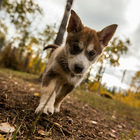
And besides, playing with a few weeks old puppies can really lighten your day as well!


We also had great time when Piia’s friends Liisa and her cousin Päivi visited us here in Yukon. We went hiking together, checked out some mountain landscapes, even went around in Whitehorse, bathed in the hot springs and the girls went horse riding as well. For Piia it was amazing to see her friend since very long time. Nothing beats spending time with close and important people!


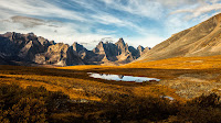
After the girls left we went to north, drove along the Dempster Highway and hiked in Tombstone Territorial Park. Nature spoiled us with its best colors and even weather was nice a few a days, except for the first night when we were under a thunderstorm with hails and snow. We shot lots of pictures and ate lots of cranberries. Recommended to everyone!


After staying a couple of weeks in Tagish we are now ready to head to Alaska again. There are some people, goats, chickens and dogs waiting for us there, and we are ready to make the most of our last weeks in the Last Frontier. And it’s snowing there already, yay!!


Sunday, September 15, 2013

Great Divide Trail hike – Stories about hiking in special conditions


Wildlife 

It was the night before we started the actual hike and we were staying in one of the backcountry campgrounds in Waterton Lakes National Park. I woke up in the middle of the night in darkness and heard weird noise outside. I woke Julien up to listen to it as well. It was a sharp, whining moan, nothing we had ever heard before. We just lay still, tried not to make any sounds of our own, or even breathe. The sound seemed to circle around the tent for a while and then go further and further away, until we only heard the waves crashing to the shore of the lake. The next day in the visitor center we talked about our night and wardens confirmed that lately a cougar has been seen near the campground. Luckily it hadn’t caused any trouble to people but was just wandering in the area. What a great reminder to whom the land actually belongs to! And from that on, we kept our ears open. 
-Piia

It was the first morning of our hiking trip. I woke up feeling the tent being pulled by someone or something. I thought Piia was kicking the fabric but she seemed to be sleeping. What the heck was going on? 

I knew we were alone in the campground so the only choice was wildlife. I sat up, just in time to see a claw scratching the tent. At that moment we were both wide awake, started making noise and clapping our hands, to scare the obviously curious bear away. We were pleased to hear it started running and then it was quiet again. It seemed the wildlife was no joke around here. Better keep that in mind. 
-Julien


It was still morning time, we were taking a break and sitting on small rocks next to the trail that headed uphill and crossed with a small creek that we used to fill our water bottles. Julien was sitting backwards to the trail and taking care of his feet while I was just enjoying my cereal bar. Then I glanced up to the trail and from around the curve there was a wolverine jogging towards us. I just stared at it, stunned to see this fairly rare animal in the middle of the day. I couldn’t even say anything at first, until it was literally two meters from Julien. I guess I must have said "Hey!" or something because suddenly the wolverine stopped, glanced at me, turned as quickly as you can imagine surprised animal doing it and ran away. Julien turned fast enough to see wolverine’s bottom disappearing behind the curve and we just stood there, quietly stunned of what the heck just happened. 
-Piia

One of the millions of tracks we saw

Snow 

We climbed the Barnaby ridge in the fourth morning and planned to follow it until its end, thinking it would offer good views over the Rocky summits. We got that right, up there it felt like being at the top of the world. It was sunny and not too windy, perfect weather. However, soon it was obvious that hiking on a ridge, especially this one, wasn’t going to be easy.


Packed snow covered the ridge in many places and even though it usually carried us, sometimes we would go through and be covered by snow until our waist. 


And of course, when there’s snow, there’s no trail, so we were basically following the ridge blind, never knowing if the trail went down, until we came to a wall that you couldn’t go down or up safely. We were wet from snow and sweat. People had told us if we started the GDT in June, we would be hiking a lot on snow. And so we did. 
-Julien


Storm 

It was after the first week of hiking and the day had been a bit foggy and rainy. We had just passed Coleman, were disappointed to leave it without having any treats and were walking on a gravel road. We saw dark, intimidating clouds getting near and we sped up thinking maybe we could get lucky and avoid the rain. Little by little the sound of a roaring thunder got near and then it started raining. Soon the thunder was straight over us; the noise broke our ears and shook the ground. The clouds were pouring water on us and soon the gravel road was just muddy surface that soaked our feet. We found a spot for our tent, hurried to set it up and dove in, being sure that the storm would be over soon and the next day would be sunny and bright. 

Two hours later rain hadn’t stopped. Not even a little. We were dozing and just waiting for the weather to clear. At some point during the night we started to really wonder when it was going to end and the later it got the more we were questioning if the sky was ever going to clear up. We heard the creek nearby getting stronger and stronger and eventually water came inside our tent as well. Little sleep and unpredictable conditions messed with our minds and in the early morning, since the rain still continued heavily, we started to wonder about how to continue the trip with the weather so miserable. We stayed in the tent until 2 pm the next day and the rain just kept going. Since we knew eventually we should continue too we packed our gear and started hiking, despite the conditions. Not knowing whether this was just normal summer storm or something else we kept hiking and forget the idea of giving up. We shouldn’t be facing anything too bad to handle, right?  
-Piia

During following days we faced something to handle for sure. Water levels in rivers were extremely high. Bridges, roads and big parts of forests were washed away. The trail was often turned into creeks. All of this obviously compromised our hiking and we faced dangerous river crossings, hiked with wet feet without seeing a dry day basically until reaching Banff, and with all that water it was hard to follow trails. Along the way it became clear that the storm had been something else than ordinary summer rain. 

When we arrived to Mt. Assiniboine Lodge and met the first people in over a week, we heard it had been a storm of a century. Many places in southern Alberta were under water and were facing enormous damage caused by flooding. People at the lodge were amazed that we had made it through the storm area, since no one was supposed to be in the backcountry. In fact RCMP was empting the area with helicopters. By luck, we were thinking, they hadn’t seen us. After all, it was another exciting story to tell. 
-Julien


Hiking without GPS or guides 

One of the biggest challenges that we were willing to take on this trip was hiking without a GPS or the guide book that is written for the GDT. We don’t like carrying a GPS in general and we were confident that my experience in hiking in mountains and our education background in geography would take us through GDT only with bad quality printed maps and a compass. We were right, we made it through. But it wasn’t easy for sure. 

A few days after the storm, while we were struggling with river crossings and trails turned into creeks, we were walking on a wide trail and knew there was supposed to be a crossroad somewhere. We found a lot of different small routes, leading to nowhere. Sometimes it was just animal tracks and sometimes it was a nice trail with red markings which wasn’t going to the good direction. According to our map we were supposed to head north but we couldn’t find any trails. So we went through a really hard bushwhacking, side walked a steep hill that was covered by wet snow and dense vegetation. We walked 10 exhausting kilometers, trying to find animal tracks to help us out. When we arrived at the other side of the hill (4 hours, a few liters of sweat and million swear words later) we found a beautiful trail marked with red tape. We figured a few hours later that this was actually the official GDT trail. Our map was just not updated; the new trail was running at the other side of the hill we just walked. 

This kind of frustrating things happened a lot during this trip. But we made it and we had lots of fun trying to find our way with the maps we had. 
-Julien