
400 km, 11 days, 10 400 m elevation gain
 Camping sites:
Minnow Lake CG in Jasper NP – Miette Lake CG in Jasper NP – Next to
Moose River in Mount Robson PP – Wolverine CG in Jasper NP – Next to
upper Jackpine River in Willmore WP – Next to mid-Jackpine River in
Willmore WP – Morkill Pass Campground in Willmore WP – Close to Cecilia
Lake in Kakwa PP – Next to upper Côté Creek in Willmore WP – Dry Canyon
in Willmore WP – Grande Cache
Camping sites:
Minnow Lake CG in Jasper NP – Miette Lake CG in Jasper NP – Next to
Moose River in Mount Robson PP – Wolverine CG in Jasper NP – Next to
upper Jackpine River in Willmore WP – Next to mid-Jackpine River in
Willmore WP – Morkill Pass Campground in Willmore WP – Close to Cecilia
Lake in Kakwa PP – Next to upper Côté Creek in Willmore WP – Dry Canyon
in Willmore WP – Grande CacheRoute: Marjorie Lake – Caledonia Lake – Minago Creek – Minnow Lake – Dorothy Lake – Christine Lake – Yellowhead Highway – Miette River – Miette Lake – Centre Pass – Miette Pass – Grand Pass – Colonel Pass
 After staying the first
night at Minnow Lake and then doing the compulsory kilometers along the
highway, the adventure began again. You can’t describe the northern
trails of the park as very well maintained routes and occasionally our
feet got muddy and wet. After reaching upper areas we crossed huge
muskegs that really soaked our shoes. Sometimes it was hard to keep
balance while fighting your way through dense willow bushes higher than
you and that meant swimming with the branches. Muskegs also made it
impossible to follow the trail and it usually took us some time to find
it again on the other side.
After staying the first
night at Minnow Lake and then doing the compulsory kilometers along the
highway, the adventure began again. You can’t describe the northern
trails of the park as very well maintained routes and occasionally our
feet got muddy and wet. After reaching upper areas we crossed huge
muskegs that really soaked our shoes. Sometimes it was hard to keep
balance while fighting your way through dense willow bushes higher than
you and that meant swimming with the branches. Muskegs also made it
impossible to follow the trail and it usually took us some time to find
it again on the other side.

The landscape changed comparing to the southern parts of the hike, passes being lower and wetter and mountains being more eroded. Not any less beautiful though!


Route: Colonel Creek – Moose River – Steppe Creek – Moose Pass – Calumet Creek – Smoky River – Carcajou Creek – Chown Creek – Bess Pass – Jackpine Pass

Mount Robson Provincial Park reminded us that this hike wasn't supposed to be easy. We bushwhaced in mud until we reached big Moose River and ended up crossing it three times before being convinced that there was no trail. We both slipped while we were in the water but it was Piia who finally fell and got herself soaked, not to mention our small camera.

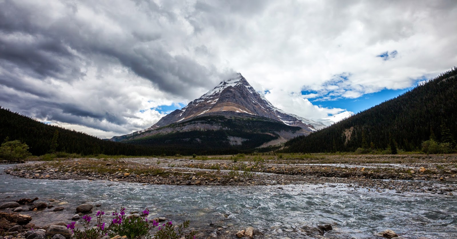
Luckily we were gradually going up which meant the ground was getting a bit drier, though it was a very rainy day. We were happy to reach the Moose Pass, especially since we saw grizzly bear happily running on the hill. It was close enough to see clearly but far enough for none of us to be disturbed. Perfect wildlife viewing! After that the section in Jasper treated us well and we were following a nice trail. Our breath was taken away by the landscape seen from Chown Creek: a mind-blowing view to the Chown Clacier.


Route: Jackpine River – Pauline Creek – Shale Pass – Shale Ridge – Morkill Pass – Mount Morkill – Featherstonhaugh Pass – Featherstonhaugh River – Forgetmenot Pass – Forgetmenot Creek – Casket Pass – Casket Creek – Sheep Creek
 Leaving
Jasper was definitely easy to notice. The trail conditions with
overgrown willows and other branches were nothing new but the climbs
were suddenly extremely steep. Then we entered Willmore Wilderness Park
that offered everything you could expect from a hiking adventure. First
we had even a closer look at the Chown Glacier (Julien’s favorite view)
since we slept basically under it and listened its moaning during our
dinner.
Leaving
Jasper was definitely easy to notice. The trail conditions with
overgrown willows and other branches were nothing new but the climbs
were suddenly extremely steep. Then we entered Willmore Wilderness Park
that offered everything you could expect from a hiking adventure. First
we had even a closer look at the Chown Glacier (Julien’s favorite view)
since we slept basically under it and listened its moaning during our
dinner. 


 Then we went through challenging and extremely wet Jackpine
River part where we couldn’t follow the trail since it went through
muskegs and on the other hand got muddy and disappeared to the river
from time to time.
Then we went through challenging and extremely wet Jackpine
River part where we couldn’t follow the trail since it went through
muskegs and on the other hand got muddy and disappeared to the river
from time to time. 


 |
| The willows didn't let us through too easily |


Of course eventually our luxurious hiking had to end and we entered muddy forests, but still we named Willmore our favorite section of the whole hike. Especially since it was the most remote section as well, and we didn’t see people for 11 days straight. Talking about luxury!


Route: Surprise Pass – Cecilia Creek – Cecilia Lake – Providence Pass – Broadview Lake – Kakwa Lake – Broadview Lake – Cecilia Lake
 After climbing snow covered
Surprise pass we saw a gorgeous view (Piia’s favorite): huge green river
valley with glaciers, snow and waterfalls.
After climbing snow covered
Surprise pass we saw a gorgeous view (Piia’s favorite): huge green river
valley with glaciers, snow and waterfalls. 


 Just like that we entered
Kakwa Provincial Park that generally meant walking again on huge muskeg
areas where sometimes ground was covered with water and willows so high
we couldn’t see in front of us. Except those shoe soaking places the
park offered a wonderful surprise with nice maintained trails on wide
alpine meadows. The mountains around us were still covered by lots of
snow and because of meltwaters the trail was occasionally very wet,
especially on low passes that was typical for this area. We established
mosquito net as our basic clothing, the high buzzing noise made our ears
ring.
Just like that we entered
Kakwa Provincial Park that generally meant walking again on huge muskeg
areas where sometimes ground was covered with water and willows so high
we couldn’t see in front of us. Except those shoe soaking places the
park offered a wonderful surprise with nice maintained trails on wide
alpine meadows. The mountains around us were still covered by lots of
snow and because of meltwaters the trail was occasionally very wet,
especially on low passes that was typical for this area. We established
mosquito net as our basic clothing, the high buzzing noise made our ears
ring. But when we reached Kakwa Lake Campground, which meant we had finally finished the GDT, nothing else mattered. We were exhausted, amazed and proud of ourselves. And it felt unbelievable finally reach that point!
 |
| Great Divide Trail (1200 km) done! |


Route: Côté Creek – Sheep Creek – Dry Canyon – Smoky River – Highway 40 – Grande Cache
Finishing the final leg of our hike meant bushwhacking around the Cecilia Lake and climbing a pass at the other side. Finding the Côté Creek was a bit challenging without a proper map but like always, eventually we found our way. Following the creek was hard since we didn’t have a trail, except for small moose routes that kept crossing on our way. We just walked in a huge valley where the ground was wet, willows slowed us down and mosquitoes kept harassing us. But on the other hand it was surrounded by amazing mountains and we had these huge meadows just for ourselves.


 |
| Last huge river crossing, water level until waist and very strong stream |
 After reaching Sheep Creek we found a trail that got
better and better the further we went, obviously because of many horse
riders using it. Last day we were able to rush and almost run on the
wide Sheep Creek and Kvass Flats trails and were eventually able to
arrive in Grande Cache the same night. And suddenlythe hike was over.
After reaching Sheep Creek we found a trail that got
better and better the further we went, obviously because of many horse
riders using it. Last day we were able to rush and almost run on the
wide Sheep Creek and Kvass Flats trails and were eventually able to
arrive in Grande Cache the same night. And suddenlythe hike was over.Although our plan wasn’t to end the hike in Grande Cache, due to medical issues we didn’t have a choice.
 |
| Feeling dirty on clean hospital sheets |
The feeling about finally finishing the trip was just indescribable and it is still hard to put those emotions into words. We felt unbelievable proud of ourselves and each other and we felt we had achieved the goals we had set for the hike.
We had conquered the
Canadian Rockies!

Hey - I just stumbled across your blog while trying to get more info on the Moose - Calumet - Smoky (-Berg Lake) route. Impressive photos!! I had wondered whether those sections of th GDT north of Jasper were worthwhile, but there's just not a lot of photos out there to go by. It would be really cool to have the photos in your album labeled as to where each is.... or even just GPS tagged, if your camera recorded that. I'm just trying to put a name to a face, so to speak, with each of the photos here. Yeah, that's a lot of work to do all that.... Anyway, thanks for sharing these photos!! They're awesome!! I can't wait to look at your albums for the other GDT sections south of here.
ReplyDelete